


About the project
This interactive geovisualization platform is created in fulfilment of the project on “Linking the Digital Humanities to Biodiversity History in Singapore and Southeast Asia”, funded by the Singapore Social Science Research Council (SSRTG Type A).

The platform displays the locality of first published records of established animal species (Animal Map) in Singapore from the nineteenth century onwards. The Animal Map page contains togglable historical maps for reference as well.

You are encouraged to ultilise the platform and the respective map layers to gain better understandings and insights of the established animal species and their associated historical vectors in Singapore.
Guide to navigate the platform
The navigation bar near the top of the page consists of three clickable tabs (Introduction, Animal Map, Credits) which will redirect you to the respective webpages:
- Introduction - This tab will lead you to the current page that we are on. This webpage contains information about the project and the guide on how to navigate the platform. You may click on this tab to return back to this webpage at any time of exploring the platform.
- Animal Map - This tab will lead you to the webpage containing the map for first published records of established animal database and togglable maps with analysis and historical maps.
- Credits - This tab will lead you to the credits section where the acknowledgements are.
Navigation within the Animal Map webpage:
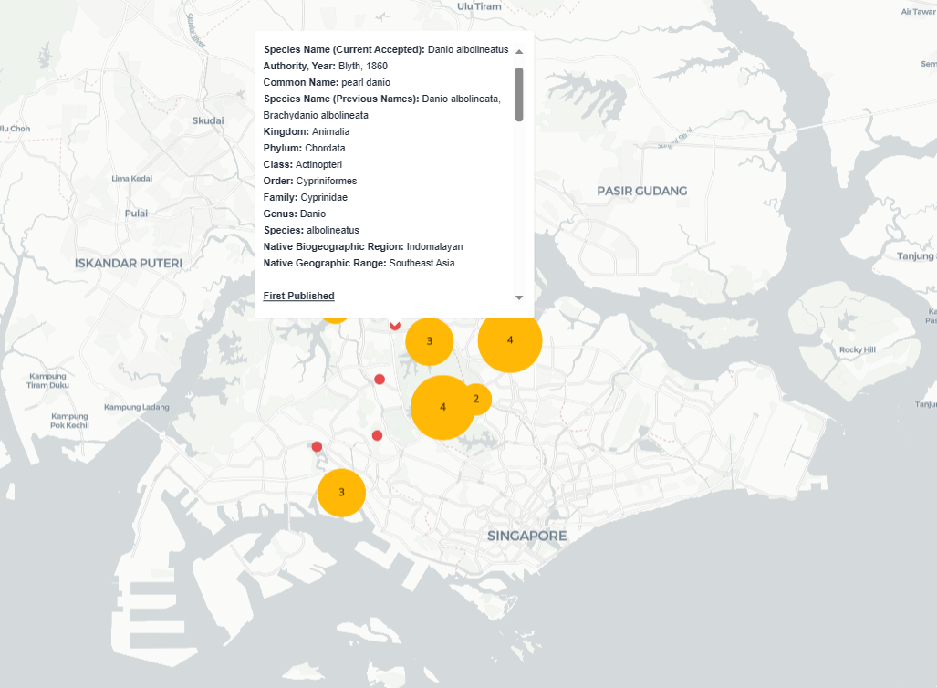
- Overview - The map webpage consists of two main sections (the map area on the left and the description and filter option control section on the right which includes the map legend).
-
Map area on the left - This section contains the view
of the maps. By default, the established animal species point map is
kept open. If you wish to hide this layer, there is a filter option at
the bottom of the section. When points are clicked on, the pop-up windows
with the details will appear. Click on any area outside the pop-up window
to close it.
-
Description and filter option control section on the
top right - This section contains the description of the map layers and
interactive components which can be used to filter what is shown on the
map view. There are a few types of interactive components:
-
Toggle switch button – This interactive component
allows you to switch from the data table view to the map area view.

-
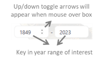
Year fill-in box - This interactive component allows
you to type and adjust in the desired year(s) of interest to show
on the map area view.
-
Option selection button - This interactive component
allows you to select the desired year(s) of interest to show on the
map area view. Click on it and the button will change to a darker
shade to show that it is selected.

-
Checkbox - This interactive component allows you
to toggle the desired historical map layer(s). Click on it and the
historical map layer will appear.

-
Toggle switch button – This interactive component
allows you to switch from the data table view to the map area view.